Welcome folks!!!

"Mountaineering is a relentless pursuit. One climbs further and further yet never reaches the destination. Perhaps that is what gives it its own particular charm. One is constantly searching for something never to be found." --  Herman Buhl 

The above is the driving force of my life

Sunday, December 14, 2008

My favorite


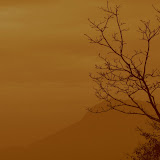
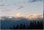
The name of the girl is Shivani. She was playing hide and seek with me. Suddenly I got her with this pose... oohh the village is Baranti at Purulia

Monday, March 05, 2007

God's own Country - Part I


We started from Bangalore at 6.00Am on 26th Jan. It was chilling and misty all around. We had our breakfast at Mandya and reached Mysore at 8.45AM. We did not enter into city. There is a left turn just before entering the city. The road is not good at all. We reached Gundalpet at 10AM and ahd some sncks there. Finally we reached Bandipur National park at 11AM. The situation was not in our favour. The safari was closed for the day. We spent some time there and returned to Gundalpet. While returning we saw some potted deers and Elephant with cub. We took the reght turn from Gundalpet. From here Kalpeta, the district town of Wayanad is only 75Km. The woad was through dense forest. We saw some elephants, deers and Jackel. This area comes under Muthunga wildlife sanctuary, also called Wayanad wildlife sanctuary. We reached Sultan batheri at arounf 2.30PM and saw Edakkal cave. Its a huge natural cave. Inside the cave is on two levels, the lower chamber measures about 18 feet long by 12 feet wide and 10 feet high and can be entered through an opening of 5 x 4 feet. A passage opposite the entrance leads upward to a small aperture in the roof through which one climbs up to the next storey whose interior is about 96 feet long, 22 feet wide, and 18 feet high. Light enters the cave through a big gap at the right-hand corner of the roof where the boulder does not touch the facing wall. Finally we reached Kalpeta at 7PM. We stayed there for that night. The next day morning we started for Suchipara water fall. The scenic beauty was spendid. The entire road was through Tea garden. It was green all around. From the roadhead it was 2 Km walk to reach the falls. We spent some time there. We had our breakfast there and started for Minmuthi falls. As per the information we had to trek for 4Km through dense forest. After starting the trek we realised that our shoe was not proper for that trek. Beside that we did not have enough water with us. The trail was though dense forest full with dry leaves. We got disbalanced for several times and exhausted soon. We saw the falls from the top and decided to come back. We came back to Kalpeta and had our lunch. We started for Kozikode in the afternoon. Meanwhile we stopped at Phookot lake (A natural sweet water lake) for five min. The place is fully commercialised and did not attract us. The road for Kozikode was through western Ghat but we could not see anything as it was dark outside. We reached Kozikode at 9PM. We spent some time in the sea beach. It was a long and tiring day for us. We had our dinner in a roadside Dhaba and went to sleep.

The next morning we got up early. We had our breakfast and went to sea for bath. The sea is calm and quiet. We took our bath till 11 'o clock. We started for Kalpeta at 11.30. We could see the entire range of western ghat. The way was throgh dense forest. We reached Muthunga wildlife sanctuary at 4PM. We did the safari, but could not manage to see any animals except spotted deer, elephants and some Bisons. But the whole safari was thrilling enough. While returning to Gundalpet we saw a group of wild elephants.

After that we came to srirangapatna had our dinner and finally came back to bangalore at 12.30AM in the night.

Thursday, December 14, 2006

Kuari Pass -- The grand stand of Garhwal Himalaya

Kuari Pass trek
The night was chilling and it was raining heavily outside. Myself, Gautam and Maroona inside the dome tent was trying to keep it standing. Though temperature outside fell abruptly, it was comfortable inside the tent. We already had our early dinner by that time. I was thinking about the early days of this trekking.

Alok-da called me up and said that they are arranging for Kuari pass trek this year. I was in dilemma, whether I would get any leave or not. Like this the plan started and somehow I convinced my project manager to get 2 week leave.

It was midnight at Bangalore when the spice jet flight took off for Delhi. After that day’s office and last moment packing I was tired also but could not manage to sleep. At the dawn the flight reached Delhi. Compared to Bangalore Delhi was very hot and humid that time. I took an auto and within 30 min reached my friend’s place near Delhi IIT. It was almost 2 years after college when I met him. Alok da and co reached Delhi at 10Am by Poorva express. We met at ISBT bus stand and set off for our next destination – Hrishikesh.

“Chai …. Chai….” The bus reached Devaprayag at 8AM after 2 hours journey from Hrishikesh. After a short break, the journey towards interior of Himalaya continued again. Around 1PM we reached Chamoli and took shelter in the temple committee guest house. It was pleasant weather in the night. According to the plan in the next day we would proceed towards Nijmula, the road head. But Krishna-di was suffering form hill diarrhea and we decided to stay for an extra day at Chamoli.

Myself, Gautam, Saibal, Maroona, Avik and Satyaki hired a jeep and had a nice trip to Chopta, the hidden beauty of Garhwal.

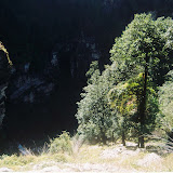
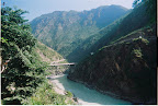
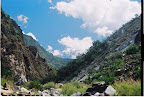
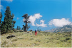
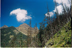
Next morning our destination was to reach Nijmula and then to reach Pagana – our 1st camp site 8km away from Nijmula. The much awaited trek starts. Rajindar is our guide. Nijmula though is very dirty, a beautiful place also. Birehi river is flowing heavily beside the village. High mountains all around. We followed left bank of the river. The track is easy. First we crossed a landslide zone and came to a bridge, 1km ahead and crossed the river. Now the entire route was through dense forest. Soon we reached Pagana.

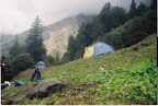
Pagana is a good camping place with plenty source of water. We pitched our three tents soon. It was 2.30PM when we reached Pagana. There was a shepherd hut beside our camping ground. We used that as our kitchen. Our lunch got prepared soon. Rice, curry and omelet was in the menu. As the place as not that much chilling, some of us took bath before the actual hurdle starts. Slowly evening arrived. Sun was yet to set. As our camping ground was surrounded by high mountains, we could hardly see the sunset but suddenly in the sky indigo appeared. All our team members came out of tent to enjoy the magnificent evening. Night arrived slowly. The only sign of lives was the lights of our tents. The Birehi river was flowing endlessly. We were a bit tired after first days trek. So we had our early dinner and went for sleep.

The next morning welcomed us by bright sunlight. Soon we got fresh and ready for that day’s trek. Our destination was Pana, 13 KM ahead of Pagana. We had our breakfast with Roti - Sabzi and started for Pana. The weather was pleasant and we had no difficulty in walking. For first one km we followed left bank of the river then started gaining the ridge of our left side. The path till the foothill was though bush and thorn. So the situation gets difficult slowly. We started gaining the ridge and within 2 hours we gained sufficient height than Pagana.

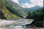
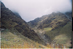
Birehi was flowing through the deep gorge as a strip of silver. In the far we could see some ice caped peaks. Rajindar told that its Nandaghunti peak. Sky was not absolutely clear. So soon after that the peak got embraced by cloud. At around 12.30Pm, after reached the top of the ridge, we decided to take lunch break. Everyone was tired. There was no shade of tree, neither a good place to sit. So we proceed further and took rest. We took our packed lunch. In this entire route we did not get any source of water. Due to sun we were sweating and got tired. We could see our yesterday’s camping ground in the far ahead. Suddenly we heard the sound of flowing water. At a distance we saw a small spring. Aaaahhh!!!! we quenched our thrust and filled our water bottles. The energy regained. Pana was not very far. We reached Pana at 4PM.

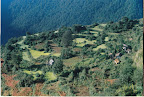
Pana is a small village in the lap of Himalaya. The village is important for Kuari pass trekkers. It was greenery all around. We got accommodation in the house of Rajindar, who basically is form the village itself. The house is called ‘Pana tourist lodge’. After we reached Pana, Rajindar went off in the jungle with his Desi-gun to hunt jungle fowl…. and we had gala dinner that night with chicken curry and rice.

We got up early in the morning. The sky was clear and we could see Nandaghunti and Trishul peak. Rajindar pointed out the trail just above the village and indicated our route. The route ascent steeply through the jungle. But this time Rajindar told plenty of water is available in the way. We had our breakfast and set for trekking. The destination was Duni kharak, 10Km away from Pana.

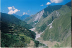
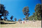
The trail goes through the Pana village first and then it entered into deep forest. We met the children of Pana and distributed toffees. As we left Pana, we saw the trail steeply raised for 200m. We started gaining the height. As we reached the top the surrounding got open around us. We could see the entire Birehi river valley and the trail we left in the last two days. Some more ice capped peaks in the Rupkund area. It was 10 Am when we reached the top.

Now the train goes though deep forest, and the experience of trekking through dense forest was unique. There was silent all around us and only some bird was whistling in the forest. The stem of the alpine trees was covered by moss and fern. Our trail was full of colorful leaves. The entire surrounding resembled as the Jurassic age. In the midway another trail met our trail. It was the famous Curzon train which comes from Jhinjhi village. We has our packed lunch with boiled egg, boiled potato and Khejur. Soon after lunch we reach Sartoli – a beautiful camping ground. From here we glimpsed Kuari pass for the first time. The high point is standing through the cloud. Sartoli is a vast ground with excellent view all around. But according to our plan, we had to proceed further 2 Km in order to reach Duni kharak.

After Sartoli the path descended through a small landslide zone. A small spring was flowing over the trail. We crossed that trail carefully. It was mud all around and trekking became difficult. After an hour and half we reached Duni kharak, a small camping ground. The ground was slightly inclined. We pitched our tents there. Guide and Gautam went to the forest to get some wood. Guide advised to have early dinner as tomorrow’s trek would be most difficult.

It started drizzling in the night. After 30min it stopped. Though we protected our tents with plastics, some water came inside of one of the tent.

In the morning Alok-da and some other members started early and we were waiting for the sunlight to come. We had another round of tea while the tents got dry. After packing we set off for that day’s destination, Dakwani kharak, the base of Kuari pass. First we crossed a bridge to cross a small stream and then started negotiating height. Sun was in the other side of the ridge. As we were in the time of leaf falling season, the entire path was full of colorful dry leaves. The trek route became harder as in every step we had to gain height. The breathing got heavier and soon after everyone got tired. At around 12.30PM we reached a flat ground whit a small stream flowing aside. We decided to take rest and have our packed lunch. The ground was much better than Duni-kharak for camping. Alok-da took out the pineapple tin from the sack. Ummmmm…. It was so delicious. We spent nearly an hour there and regained our energy. Now we were about to cross tree line. We crossed pine forest and entered in grassland. The other side of the mountain was glittering by sunlight and Sartoli was visible too. Here the Kuari pass was not visible though cloud. The track was clearly marked by stone. Other than the height gain we did not have any difficulty in trekking.

At around 4PM we reached Dakwani kharak at the foot of Kuari pass. The weather got cleared soon and we could see our next day’s destination. It was nearly 1000ft we had to gain through loose boulders. In the opposite side Nandaghunti was clearly visible too. We pitched our tents. Dakwani was above the tree line and due to the height, it was much colder than the other camping grounds. While taking the tea in the evening we could feel the cold. Soon we were surrounded by cloud. Nothing was visible within 5/6 foot too. To reach from one tent to other we had to use torch signaling. The situation got worse when it started raining. It was 7PM when we had our dinner by egg curry, rice and dal. Soon the raining turned into storm. It became a nightmare as we had to hold our tents to protect it from being fallen. At around 11PM the weather got settled. We came out of the tent to see the condition. The place was surrounded by cloud and we could not see anything.

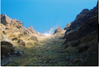
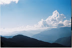
We wake up early in the next morning guessing snowfall on the pass in the previous night. But there was no such trace. So we started at 8AM and started gaining height. Due to yesterday’s heavy rain the boulder was loose and we were very careful. The track was not prominent and we were approaching in our convenient way towards the top. Last hundred feet or so was really tremendous tiring. At around 9.30 we discovered that there were no more trail to go up and the entire Himalayan range is shinning infront of us. Almost in 180° the peaks were around. Nilkanth, Hati Ghori, Kamet Abigamin and of course Nandadevi!!! We are standing on Kuari pass right now. Wind was blowing gently. We performed puja to great Himalaya. Again the weather was getting worse and none of the peaks was visible anymore. We started descending towards Khulera. The trail was much easier and beautiful too. It was dry grass land and meadow all around. Sometime we crossed small ice patch. Soon we came down to tree line. The path goes through the dense pine forest. Soon we reached Khulera, that day’s camping ground at around 1PM.

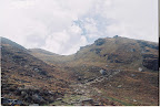
Khulera is most beautiful camping ground in this trek. With plenty of source of water and woods for cooking it has panoramic view of Himalaya. There is a high point nearby, where we went in the evening to take photographs of Nilkantha and Nandadevi.

The night was chilling and wind was flowing gently. We already had our dinner at 8.30PM with fried rice, egg curry etc. It was our last camping ground before we reach Josimath. We had another round of tea before we went for sleep.

The next day we arose at 6AM. We again went to the high point to shoot some photographs during sunrise. This time Himalaya did not turn us down. We could see spectacular view of Himalaya which we expected to see form the top of Kuari pass but due to bad weather we could not. 
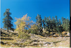
We came to the camp and after heavy breakfast started descending for Tapavan, the road head. The trail first went through deep forest. To take short cut route some time we fell down. After that the path went though landslide zone. We had to be very cautious as the loose boulders were trying to fall us down. At around 2PM we were in the opposite side of the Gorson meadow. There is another trail which ends at Auli from Gorson. The trekkers who do Kuari pass trek from Auli side follow that route. Dehli river was flowing in between us. We had finished up drinking water with us by that time. We decided to take rest and have lunch.

After the lunch we started descending again. Now we could see Dhauli-ganga river and the road towards Malari. Our track was through the village. We met few villagers and given them some useful medicine. Now we could see Tapvan, our destination. Within 15-20 min we reached Tapvan. Due to whole day’s exhaustion, we were very tired. We had tea and snacks in a nearby hotel. Soon we hired a jeep and went for Josimath.

I can tell you know the whole story about Josimath, Auli and how we came to Delhi etc, but I really don’t want to. I want to end up here. We are very small creature to mountains. Mountains can not be conquered; we can only keep our footsteps somewhere. Himalaya is vast and all of its various parts are equally rich in terms of bio-diversity. Somewhere it has white glacier and peaks, and somewhere it welcomes by green forest, deep blue sky and rivers.

Trek is not all about mountains. There are parallel stories of the simple villagers of Pana, the shepherd we met in Dakwani and lala-ji of Nijmula. It’s not only a story of 6 days struggle and gaining heights, it’s rather a philosophy which is beyond of all measures. It adds a new height to the mountains which never be scaled.


Monday, December 05, 2005

Sujoy ke niye lekha

SUJOYSHREE

OO AAMAR SWOPNER PREMIKA JOY, TOMAR SMS DEKHE MONE JAGE BHOY,
BUK KORE DURU-DURU,
KOTO KHANE DHIL KHEYE, KOTO GHAT E JOL KHEYE, AAJ EKHANE AAMRA DUJONE,
AAMAR SARA TOMAR SURU.

OFFICE E KAAJ KORTE KORTE TOMAY BHAEBE LAGTO BESH,
CHATROOM-E TE MOJE GIYE LIMA’R GOLPO KORECHI SES.

JOYITA AAMAR PREMIKA CHILO, EKHON HOYECHE BON,
AASAY AASAY ROYECHE SMITA, FURALO PROYOJON.

SMITA’R KOTHA BHULE GIYE JIBON-MORON PON KORECHI, TOMAY PABO BOLE,
WEBPAGE E JIBON-SATHI, KHUJTE TOMAY, TAI BOSECHI KHULE.

LOKKHO E-MAIL KORECHI TOMAY HAJAR KAJ-ER MAJHE,
PREM-E PORA TAI FASHION AAMAR, ROJ SOKAL SANJHE.

AAMAR MONER STACK E SUDHU POP AAR PUSH,
RAT-BIRETE OONDHOKAR-E ‘DIL’ KORE UUS-KHUS.

UUKUN NOY, CHULKANI NOY,
E HOLO GOVIR, E HOLO PREM-ER DANDHA,
MAIRI BOLCHI !! BISWAS KORO,
TOMAR PREM-ER LAMPPOST-E, AAMAR PREM-ER CHAGOL BANDHA.

Wednesday, November 10, 2004

My Experience of Ton's Valley Trekking Expedition

MY EXPERIENCE OF TON’S VALLEY TREKKING EXPEDITION 2004

Organized by: - SOUTH CALCUTTA TREKKER’S ASSOCIATION


Team members: - Dr. Aloke Sil (Leader), Mrs. Krishna Sil, Abheek Sil, Partha Sil, Dibyendu Seal (Qr master), Dr. Mushtaque Alam(Equipment incharge), Dr. Saibal Mishra(Treasurer), Meroona Murmu.

Duration: - 12th Oct to 29th Oct 2004

15th Oct: -
Our jeep started at 8.30AM from Sankri. It was proceeding slowly through dense rainforest towards Taluka. We had a big family of 8 members, 6 porters and 1 guide. The road was not good at all. We saw several landslides around us. But the scenic beauty of the journey was enough to keep us moving. The entire route was through Govind Wildlife Sanctuary and there we saw several waterfalls, small in size but beautiful in nature. Suddenly we saw some ice peaks, in the distance. Tomorrow we shall go to explore them this thought left us delighted. The beautiful journey of 14Km ended at Taluka.

We hired the PWD Banglow for our accommodation and soon got engaged in the preparation of our lunch. Taluka is a small village in the lap of Himalaya and the main occupation of the villagers is terrace farming. We saw fields of Potato, Ramdana etc. Ton’s river is flowing just beside of the village. Through out the whole day and night we heard her song.

There are several trekking routes starts from Taluka, viz. Fatchukandi Pass, Manjukandra Pass, Ruinsara Tal etc. Our destination is to visit the valley of goddess- “Har-ki-doon”.

16th Oct: -
We completed the necessary packing in the previous night. It was a bright sunny morning and some Cirrus clouds were roaming around the sky. After a heavy breakfast our trek began. The first 2Km of the route was through the true left bank of the river. After leaving the village area we walked through narrow trek line. Then we crossed a small bridge over “Tatmir nallah” and relaxed our tired legs for a while on grassland. Up to this, we faced hardly any ups and downs. After that the route was through dense rain forest and slowly we started gaining height. It was somewhat treacherous for 1st days trek, as we had to negotiate with soft mud and rotten leaves. Our shoes were getting stuck into it. We saw a large caravan consisting of hundreds of sheep coming from ‘Debsu Bugiyal’ and the local ‘Bakhriwala’ informed us that ‘Debsu’ was under a foot of snow and the camping ground of ‘Ruinsara’ was snow covered two days ago which was not likely to melt.

After 6Km trek we reached ‘Gangar’ village and took some tea and packed lunch. After taking rest of ½ an hour we started walking. Tamasa was flowing through deep gorge, so we did not glimpse at her. Now we started entering in the deep forest of Seema. We were walking through light and shadow of pine trees. This was somewhat less tiring for us as the intensity of ascending was less than before. One of our members was not feeling good due to foot injury. Around 5PM we reached Seema (8000 ft), another small and beautiful village in the bank of Tamasa. We hired the PWD bunglow for our accommodation. We saw patches of snow hither and thither. The night was chilling, so we took our dinner soon and went to sleep.

17th Oct: -
We left Seema around 8AM. It was very cold as the sun was still behind the high mountains. We changed our plan a bit after discussion with the Guide and the villagers of Seema. We crossed the hanging bridge over Tamasa and came to the true right bank of the river. We started ascending through the boulders and bushes. After some time we reached the track of ‘Har-ki-doon’ and took rest for a while. Then the route seemed easier to us and we enjoyed every moment. We noticed ‘Debsu’ fully covered with snow in the opposite bank of the river. We were surprised when we reached ‘Seematra Bugiyal’. There was all greenery around us and sheeps were roving. After crossing a waterfall we started gaining height again. At around 12PM we reached ‘Kalkatti dhar’. From here we glimpsed at “BLACK PEAK”, “BANDARPUNCH”, and “SWARGAROHINI”. We saw the crazy ‘Ruinsara’ river getting combined in ‘Tamasa’. After that the main hurdle of the trek began. We started ascending the steep elevation of ‘Kalkatti dhar’. We had to slow down due to ice patches in some places. The either side of the mountains turned white due to heavy snow fall. We met another team of Kolkata and came to know about the huge snow in the ‘Har-ki-doon’ valley.

At around 4PM we started ascending through snow covered track and within ½ an hour we reached on the top of the ridge. For the 1st time we saw the valley of ‘Har-ki-doon (11500 ft)’ in the lap of ‘SWARGAROHINI’. Seeing this heavenly place I could not able to resist my tears of joy. The combined stream of ‘Morinda nallah’ (Coming from the Glacier of Borasu pass) and ‘Har-ki-doon nallah’ (Coming from Jaundhar glacier) is flowing through the middle of the valley. The entire valley was covered with snow and some chunks of ice were flowing through the river. After crossing a natural bridge we came to the PWD banglow. The sun was setting. The entire sky was getting more and more reddish and ‘SWARGAROHINI’ was seemed to be a picture painted beautifully by some heavenly artist.

At around 7PM I came out of the Banglow. It was dark around us. The sky was full of stars and it was too chilling. The temperature felled 5 degree below zero. We took our dinner at 7.30PM. One of our members was ailing of altitude sickness. So our doctor prescribed him some medicine.


18th Oct: -
We were welcomed by the bright sunlight of the morning and after taking some food we started for ‘Morinda Tal’. We crossed previous day’s natural bridge and started ascending. At 1st we moved through some snow patches which soon turned into deep snow. To protect the feet from frostbite I advised everyone to wrap plastic over the socks. Soon we reached a snowfield. Some of our members were not interested to go up due to snow. So two of our members, Ramlal (Guide) and myself started ascending again. It was deep snow all around and in some places it was about 3ft deep. We were ascending in the route created by the footsteps of Ramlal. There was some risky slopes but we were confident and physically fit to establish the camp at ‘Rathador’.

Suddenly Mushtaque lost his balance and slipped. This caused no major injury but his sunglass was broken. Fearing of snow blindness he returned to base camp. Now we could see the ‘Borasu peak’ far apart from us. The total ‘Swargarohini’ group was shining brilliantly in daylight. Now we were in the height of 13000ft. We started climbing through boulder zone and hardly faced any difficulty. We saw ‘Morinda’ coming down as a waterfall through the ice. We took some rest there and again started negotiating with ice. We reached ‘Morinda Tal (14000 ft)’. We performed puja and some ritual gesture to the God there. The other member was not interested to establish camp there and she wanted to return ‘Har-ki-doon’. It was 12’o clock and the ice had begun to melt. So we abandoned our plan and returned to base camp. Descending through snow was not easy work. We started stamping and came down safely. We exchanged our experience with each other and decided to return to ‘Seema’ on the very next day.

19th Oct: -
We left ‘Har-ki-doon’ at 7.30AM and without much difficulty reached Seema at 4PM. We noticed that the entire snow of ‘Debsu’ had melted keeping only some patches. So we decided to establish camp in ‘Debsu’ on the very next day and attempt ‘Ruinsara Tal’ if possible. So we packed our ration, tents etc.

20th Oct: -
We left Seema at 8AM. Keeping the bridge over Tamasa in the left we took the true left bank of the river. After crossing a waterfall we started gaining height very slowly. Due to hard snow we had to be careful too. It caused ver-glass over boulders, very slippery in nature. Except this there was no difficulty in the route. After 3hours walk we reached in a broad valley- ‘Debsu’. The beauty of ‘Debsu’ mesmerized us. Flat green grassland all around with some snow patches and ice peaks, though they were not clearly visible due to gathering of alto-cumulous cloud in the sky. In spite of having sun the weather was not fully clear and a gentle wind was blowing. We walked another Km and pitched our tents near the source of water.

After lunch, at around 1PM we left our camp to observe the condition of our next day’s way. From ‘Debsu’ we started coming down towards the riverbed. The entire route was through dense forest covered with ice, which even in the afternoon was in hard packed condition. We slipped several times. We reached the ‘log’ bridge of ‘Ruinsara’. The entire scenic beauty had spell bounded us. ‘Ruinsara’ river, coming from the icefall of ‘Bandarpunch glacier (8Km from ‘RuinsaraTal’)’ was flowing robustly through the gorge of sky-scraping mountains. We noticed some landslides in the other side of the river, through which we had to go for ‘Ruinsara Tal (11200 ft)’. We did not find any convenient way to reach ‘Ruinsara Lake’ safely for such an inexperienced team. After discussing with leader about all feasible ways we abandoned the ‘Ruinsara Tal’ programme for the safety of the team. The weather was not clear at all and in this condition, attempting ‘Ruinsara Tal’ would be an unnecessary risk for us.

21st Oct: -
We left our camp at 9AM and reached Seema at 12PM. We visited ‘Osla’ village and temple of ‘Duryodhan’. Our doctor gave some necessary medicines to the villagers. We spent the whole day by freaking out, eating and gossiping.

22nd Oct: -
Our last day of trek. We started for Taluka at 7.30AM and reached there by 2PM.

We spent another day in Taluka.

In this trekking programme we had planned to go up to ‘Kyarkoti (14000 ft)’ and ‘Deobasa (15500 ft)’. We were absolutely mentally and physically fit and we had sufficient rations and fuel for those days. From ‘Seema’ to ‘Ruinsara Tal’ is 15Km trek, which can be completed in one day. Due to snow we had to stay at ‘Debsu’ and we were perplexed whether the camping ground of ‘Ruinsara’ would be snow covered or not. Besides this the weather was not good at all and we feared that there would be snowfall. In the entire programme we had to negotiate with a huge amount of snow, which was beyond our thought. In this situation, we had no other alternative but to move back. As the time passed we got a clear view of the total event. The failure of ‘Ruinsara Tal’ programme has given us more experience and courage than many other successful trekking programmes in the past.

“We never achieve mastery over the mountains; the mountains are never conquered …….. The climbing game is a folly…….. in the context of discovering one self, testing the limits of one’s ability, exploring the boundaries of fear, determination and endurance, climbing is a means of self fulfillment and a source of great satisfaction” --- Joe Tasker